Coordinate Transformation
Introduction
Coordinate Transformation (Projection) is the process of tranforming the spatial data from one coordinate system into another. The new tranformed spatial data can then be downloaded.
1. Select the input data

- Input Data: Spatial data only.
2. Select the output coordinate system
-
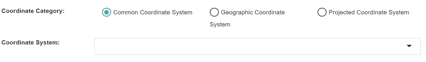
Coordinate Category: Coordinate systems are divided into “Common Coordinate System”, “Geographic Coordinate System” and “Projected Coordinate System” for the purpose of selecting the required coordinate system.
-
Coordinate System: Support for converting to various types of coordinate systems. Projected coordinate systems are classified by datum. You can input keywords to find the desired coordinate system.
3. Set the output data

- Output Data Name: If no name is set, the default is “toolName_time”.
4. Submit
After completing the above settings, click Submit to start the tool.
When it finishes successfully, a message will be shown at the top of the page. you can click the download button of the corresponding data in the calculation record on the right to download the transformed data.
About the Coordinate System
Coordinate systems can be divided into Geographic Coordinate System and Projected Coordinate System. Geographic Coordinate System is spherical coordinate, the reference plane is ellipsoidal, and the coordinate unit is latitude and longitude; Projected Coordinate System is plane coordinate system, the reference plane is horizontal, and the coordinate unit is meter, kilometer, etc. The process of converting Geographic Coordinate System to Projected Coordinate System is projection, that is, converting irregular earth surface to plane. There are various ways of projection, such as Universal Transverse Mercator Projection (UTM), Lambert Equirectangular Conic Projection (LCC) and so on. Some projection methods will divide the plane into different zones to reduce the distortion caused by the projection process, so each geographic coordinate reference plane can produce a variety of projected coordinate systems.